Western Cape - Analyse the risk
More about future scenarios & solution strategies
About future scenarios
Two future scenarios with changing climatic and socio-economic conditions were analysed for the WCWSS: the Middle of the Road Scenario and the Rocky Road Scenario. The Middle of the Road Scenario represents a future with limited socio-economic changes and moderately drying climate. It is based on the socio-economic scenario SSP2 and the climate scenario RCP4.5. The Rocky Road Scenario represents a future with reduced economic growth, socio-economic fragmentation and significantly drying climate. It is based on the socio-economic scenario SSP3 and the climate scenario RCP8.5.
About mitigation strategies
One preferred water scarcity mitigation strategies was developed in the basin. By selecting a mitigation strategy, the impact of the strategy on the water demand, water availability and water gap per municipality is visualized. Also, the changes in (relative) risk for the sector and user groups can be viewed. More information about the preferred water scarcity mitigation strategy for this basin can be found in [section 4.1](#4.-Preferred-mitigation-strategy).
1. Water Scarcity Risks
1.1 Introduction to the area
The Western Cape case study area considers 6 municipalities from the Western Cape province of South Africa. Due to increasing periods of droughts and socio-economic changes, the water availability from the reservoirs in the area is under pressure. To achieve water security in the area, several mitigation measures have been planned.
The WaterLOUPE water scarcity risks dashboard calculates and presents the relative risks for different sectors and users in the Western Cape municipalities, now and in the future, with and without the planned solution strategy.
More information Western Cape area
The Western Cape case study area considers 6 municipalities from the Western Cape province of South Africa. These municipalities are Cape Town, Swartland, Saldahna Bay, Stellenbosch, Drakenstein, and Bergriver. Between these municipalities there are significant variations in terms of urban and rural areas, industrialized or agricultural areas, socio-economic status, and the presence of protected nature. The biggest city in this area is Cape Town, positioned in the south-west near the coast.
The regions’ water supply is organized and distributed by the Western Cape Water Supply System (WCWSS). Due to increasing periods of droughts, the water availability from the WCWSS, that relies for the largest part on reservoir water, is under pressure. In addition, the demographic and economic changes in the Western Cape area lead to an increase in water demand.
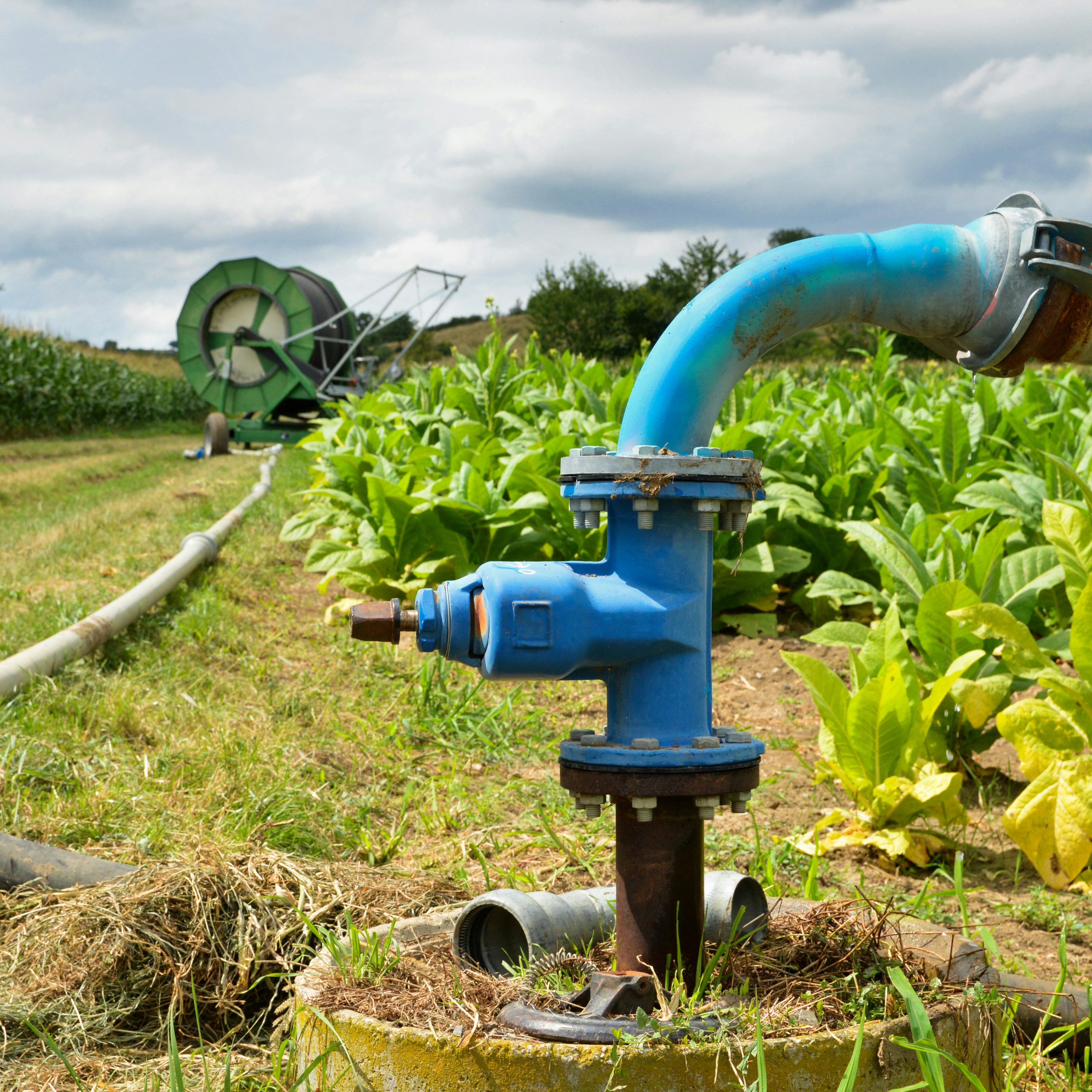
The combination of increasing water demand and decreasing water availability poses threats to the different economic sectors and water users in the area. To achieve water security in the area, several mitigation measures have been planned by the Department of Water and Sanitation of South Africa. Examples of these proposed measures are additional groundwater abstraction, increase of surface water reservoir capacity, increased water re-use, and desalination of sea water.
The WaterLOUPE water scarcity risks dashboard calculates and presents the relative risks for different sectors and users in the Western Cape municipalities, now and in the future, with and without the planned solution strategy.
1.2 Overview of risk levels
Explanation map and table
This map and table show per municipality which the water scarcity risk level for the different sectors present. By selecting a municipality and sector in the drop-down menu's and by shifting the time scale bar, specific risk information can be visualized in the map and shown in the table.
Legend
Low risk 0 1 2 3 4 5 6 7 8 9 High risk
Water user not present -
Note: WaterLOUPE water scarcity risk analysis, including the water gap estimations and risk calculations, is purely indicative. The analysis is based on a combination of global and local data sources, that were only validated to a limited extend. Future scenarios are not certain, but rather give an impression of the possible changes in watergap (distribution) and related risk for sectors and user groups.
1.3 General observations
- Western Cape faces serious water scarcity risks. Currently, a water gap only occurs during dry years and dry seasons. Towards the future, the occurrence of a water gap will be more frequent and is expected to become a structural problem in the western cape area. This is the result of both dryer future climatic conditions as well as an expected increase in the water demand, driven by population increase and economic growth.
- The municipalities in the western part of the Western Cape study area (Saldana Bay, Swartland, and Cape Town) face the highest water scarcity risks, both now and under future scenarios
- Poor households, self-subsistence farmers, and nature/biodiversity are most vulnerable to water scarcity and therefor show higher risk levels. In Cape Town and Saldana Bay, the water demand of industries is relatively high and is expected to increase in the future. As a result, the water scarcity risks for this sector are high in these municipalities.
- The policy measures in the period 2017-2019 (water restriction measures, improved metering, awareness campaign) significantly reduced the water use in the basin. Whether this will lead to a structural decrease in water demand is not yet clear.
- The developed water scarcity solution strategy combines several measures that increase the water availability during dry periods: increase the capacity and number of surface water reservoirs, increase groundwater extraction, stimulate and increase water re-use, and desalination.
- This strategy significantly reduces the water gap and water risks in the basin. However, on the longer term (after 2040), a water gap is still expected to occur on a yearly basis. The sectors with high water demand and the vulnerable user groups will still face risks, even when the developed strategy for mitigative measures are fully implemented.
2. Risk Assessment
2.1 Calculation approach
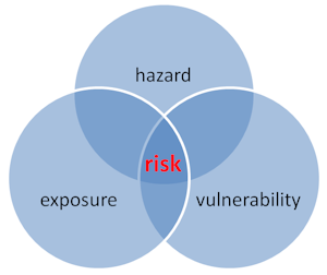
The WaterLOUPE water scarcity risk analysis shows the relative risks for the different sectors and user groups, now and in the future. The presented risk level of the area is the result of a combination of the hazard (drought conditions, reduced water availability), the exposure of water users in different sectors (domestic, nature, and economic) and the vulnerability levels of the different water users in the basin.
The following sections break down these different components that jointly lead to the presented water scarcity risks.
More on our risk calculation method
Water Scarcity Risk
In the classical approach to water scarcity or drought risk assessment, vulnerability factors are combined with information on hazard and exposure to assess drought risk (see Figure). The magnitude of a drought event, the exposure and vulnerability information together determine the impact of that specific drought event. In other words, the impact of a drought event is determined by hazard x exposure x vulnerability. Before the risk levels are computed, the watergap is reclassified and the proxy values for exposure and vulnerability are normalised. Finally, the risk levels are rescaled between 0 (very low, green) and 9 (very high, red). As a result, the presented water scarcity risk levels are relative risk levels within the basin.
In WaterLOUPE, water scarcity risk is expressed by risk level categories (low risk to very high risk). These categories are estimated using a combination of the severity of the watergap (see sections 2.1-3) and proxy values for exposure (e.g. GDP, km2 agricultural area) and vulnerability (e.g. population below poverty line, GDP per capita). In case a specific risk category does not occur in a sub-basin, it is assigned a risk level of -1 (grey). More information about exposure and vulnerability can be found in section 2.4.
Reclassification watergap
Once the watergap is calculated, we reclassify it in values between 0 and 1. This reclassification is done based on the average watergap of the period of analysis according to the following method:
- If a given month has a negative watergap (i.e. scarcity), then watergap = 1 = very high hazard
- If a given month has a positive watergap smaller than the 10 percentile watergap for the period of analysis for that given basin, watergap = 75 = high hazard
- If a given month has a positive watergap > than the 10 percentile and < than the 25 percentile watergap of the period of analysis for that given basin, watergap = 0.5 = moderate hazard
- If a given month has a positive watergap >than the 25 percentile but < than the median watergap of the period of analysis for that given basin, watergap = 25 = low hazard
- If a given month has a positive watergap > than the median watergap of the period of analysis for that given basin, watergap = 0 = very low hazard
Data use policy
For the WaterLOUPE risk assessment data about hazard, exposure and vulnerability is required for each sub-basin. In many cases, local data is not available for all aspects of the water security risk assessments. Hence, national data or global data sets are consulted to supplement the local information. The data use is prioritized according to the following rules:
- If local data is available for the appropriate time window, this local data is validated and used. Often rescaling of the data is required before it can be used for the risk analysis.
- If local data is not available, but national data is available for the appropriate time window, the national scale data is validated and used after rescaling to local levels.
- If no local or national data is available, output from the global water model PCR-GLOBWB is used. This model output is available at monthly time-steps and a spatial scale of 10x10 km. Important here that the output information is validated by local information and knowledge, before it is used in the risk assessment computations.
References
- Assessing water related risks to the industry and other stakeholders in 2 basins in Colombia. Deltares report (2017)
- Mapping global patterns of drought risk: An empirical framework based on sub-national estimates of hazard, exposure and vulnerability (2016)
- Global inventory of drought hazard and risk modeling tools. Deltares report (2018)
- Documentation global water model PCR-GLOBWB.
- Comparative Assessment of Drought Hazard and Risk Modeling Tools (2018)
2.2 Water demand and availability
Explanation bar chart
This chart provides information about the water demand from the different sectors and the water availability in the selected sub-basin. The information is shown for four 10-year periods: 2010 - 2020, 2020 - 2030, 2030 - 2040, and 2040 - 2050. For each period, the average water demand and availability are shown.
More information
Water demand is the sum of industrial, domestic, and agriculture (livestock and irrigation) water demand.
References
Assessing water related risks to the industry and other stakeholders in 2 basins in Colombia (2017)
2.3 Watergap over time
Explanation graph
In this graph information can be obtained about the water availability and the water demand in the selected sub-basin for the period 2010 - 2050. The graph presents monthly averages of water availability and water demand.
More information
Watergap = water demand – water availability
For the total basin and the sub-basins the current and future water availability and water use were computed. This gives a quantitative estimation of current natural water availability as well as water use by the different sectors (irrigation, domestic, industry, and livestock).
With this information we calculated a water balance to identify the watergap per sub-basin and per month for three 10-year periods: 2010-2020, 2020 - 2030, 2030 - 2040, and 2040 - 2050.
Local climate scenario
For the purpose of WaterLOUPE future water shortage risk calculations, a RCP climate scenario was used.
Local socio-economic scenarios
Based on the narratives for the socio-economic scenarios, changes of indicator values of exposure and vulnerability of the main sectors / user groups were deducted for the local situation of each sub-basin. This provides information on the impact of the different SSPs on water use.
References
2.4 Exposure and vulnerability to drought
Explanation map and table
Exposure and vulnerability are an essential part of water scarcity risk. The map and table in this section provide relevant exposure and vulnerability information (proxies) for each municipality in the Western Cape area.
More information
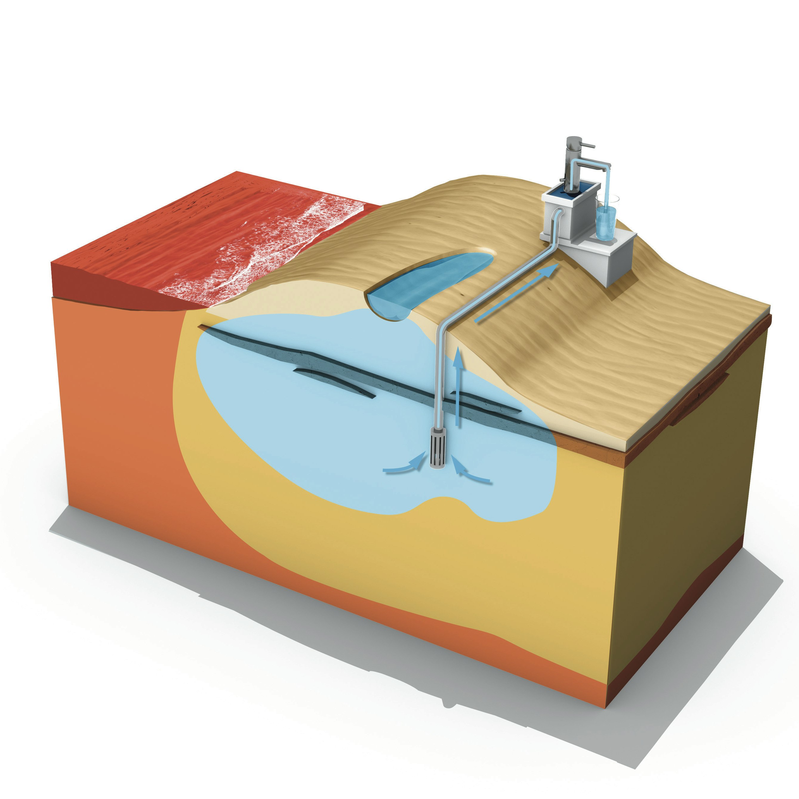
Exposure
Exposure to drought comprises all assets and sectors located in a drought-prone area. Examples of sectors that are susceptible to droughts and are relevant to include as exposure in a drought (risk) assessment are: agriculture, energy and industry, drinking/domestic water supply, navigation, ecosystems, tourism, forestry, aquaculture and fisheries, and the financial sector (investors, insurances, asset owners).
In a drought or water scarcity risk assessment it is important to collect data on exposure characteristics (proxies) that will influence the magnitude of the potential impact of the drought or water scarcity. Population relying on each sector (for income, food supply, water and electricity supply, etc.) and the economic value of each sector are relevant exposure characteristics to determine the impact of drought for all sectors. For example, the larger the share of exposed GDP, the larger the potential impact of a drought on the economy of a country.
Vulnerability
The magnitude of the impact of a drought or water scarcity event depends on the vulnerability of the exposed assets and sectors. Here, vulnerability can be referred to as the predisposition of assets or sectors to suffer adverse effects when exposed to a drought event. The level of vulnerability to a drought or water scarcity event is determined by the intrinsic characteristics of the asset or sector. For example, certain crop types are more vulnerable to droughts than others; and proximity of a drinking water plant to the coast makes it more vulnerable to salt intrusion during a drought. Therefore, it is important to collect the intrinsic exposure characteristics for the asset or sector as addressed in the exposure section above. In case such detailed information is not available, vulnerability can be assessed in a more generic way in which a distinction is made between three categories of vulnerability indicators: social, economic and infrastructural indicators. For each of these indicators proxies have been identified to quantify the level of vulnerability:
- Economic vulnerability can be quantified by proxies like energy consumption per capita; agricultural value added (% of GDP); GDP per capita; poverty headcount.
- Social vulnerability can be quantified by proxies such as the percentage of the population below poverty line; literacy rate; improved water sources; life expectancy at birth; population ages 15-64; refugee population; government effectiveness; human development index; disaster prevention and preparedness finances; conflicts.
- Infrastructural vulnerability can be quantified by proxies like agricultural irrigated land; % of retained renewable water; recycling ratios; irrigation efficiencies; road density; age of the infrastructure.
Selected proxies for this basin
To quantify te levels of exposure for each risk category, the following proxies were selected: percentage areas of land use types, population density and personal consumption expenditure or gross domectic product (GDP). This selection of proxies was based on data availability and discussions during the stakeholder workshop.
To quantify te levels of vulnerability for each risk category, the following proxies were selected: personal consumption expenditure or gross domectic product per person (GDP per capita), percentage of rural population, percentage of the number of people whose income falls below the poverty line (poverty rate), percentage of the number of people who live in extreem poverty (extreme poverty rate), percentage of the number of people that are aged below 15 (population below 15). This selection of proxies was based on data availability and discussions during the stakeholder workshop.
References
- Assessing water related risks to the industry and other stakeholders in 2 basins in Colombia. Deltares report (2017)
- Mapping global patterns of drought risk: An empirical framework based on sub-national estimates of hazard, exposure and vulnerability (2016)
- Global inventory of drought hazard and risk modeling tools. Deltares report (2018)
- Exploring drought vulnerability in Africa: an indicator based analysis to be used in early warning systems (2014)
3. Solution Strategies
3.1 From risk assessment to solution strategy
A next step when improving the water security in a basin, is the development of water scarcity solution strategies with all stakeholders. The solution strategies are expected to improve the water security at short to medium time scales, but should also enable the possibility to adapt to future changes (both climatic and socioeconomic).
In the first phases of the development of solution strategies, the results of the water scarcity risk analyses provide information to prioritize areas, sectors, and user groups with high risk and basin characteristics needed to evaluate the technical, environmental, financial, economic and political suitability of measures in that specific basin.
3.2 Developing solution strategies
To compose a water scarcity solution strategy, various mitigation and adaptation measures need to be combined. To evaluate the suitability of measures for the specific basin information about their physical, environmental, socio-economic, and political characteristics context should be clear to all stakeholders.
WaterLOUPE 2.0 contains an information catalogue that provides such information for a range of water scarcity solution measures:
Information catalogue of water scarcity mitigation and adaptation measures
3.3 Solution strategy Western Cape area
For the Western Cape Water Supply System, a water scarcity mitigation strategy was developed by the Department of Water and Sanitation of South Africa (directorate National Water Resources Planning). The table below shows the mitigation measures that were selected for the strategy, as well as the estimated yield, lead time, and year of implementation of each measure. More information of the development of this mitigation strategy can be found in the report from the WCWSS: WCWSS Status Report Oct2014 Final.pdf (dws.gov.za).
| Measures selected in preferred strategy | Yield (x 1.000.000 m3/y) | Lead time (years) | Year of implementation |
|---|---|---|---|
| 1. Increase surface water reservoir (Voelvlei) | 23 | 7 | 2022 |
| 2. Groundwater abstraction (TMG scheme 1) | 20 | 8 | 2024 |
| 3. Re-use water (option 1) | 40 | 8 | 2025 |
| 4. Groundwater abstraction (TMG scheme 2) | 30 | 9,5 | 2027 |
| 5. Re-use water (option 2) | 40 | 8 | 2029 |
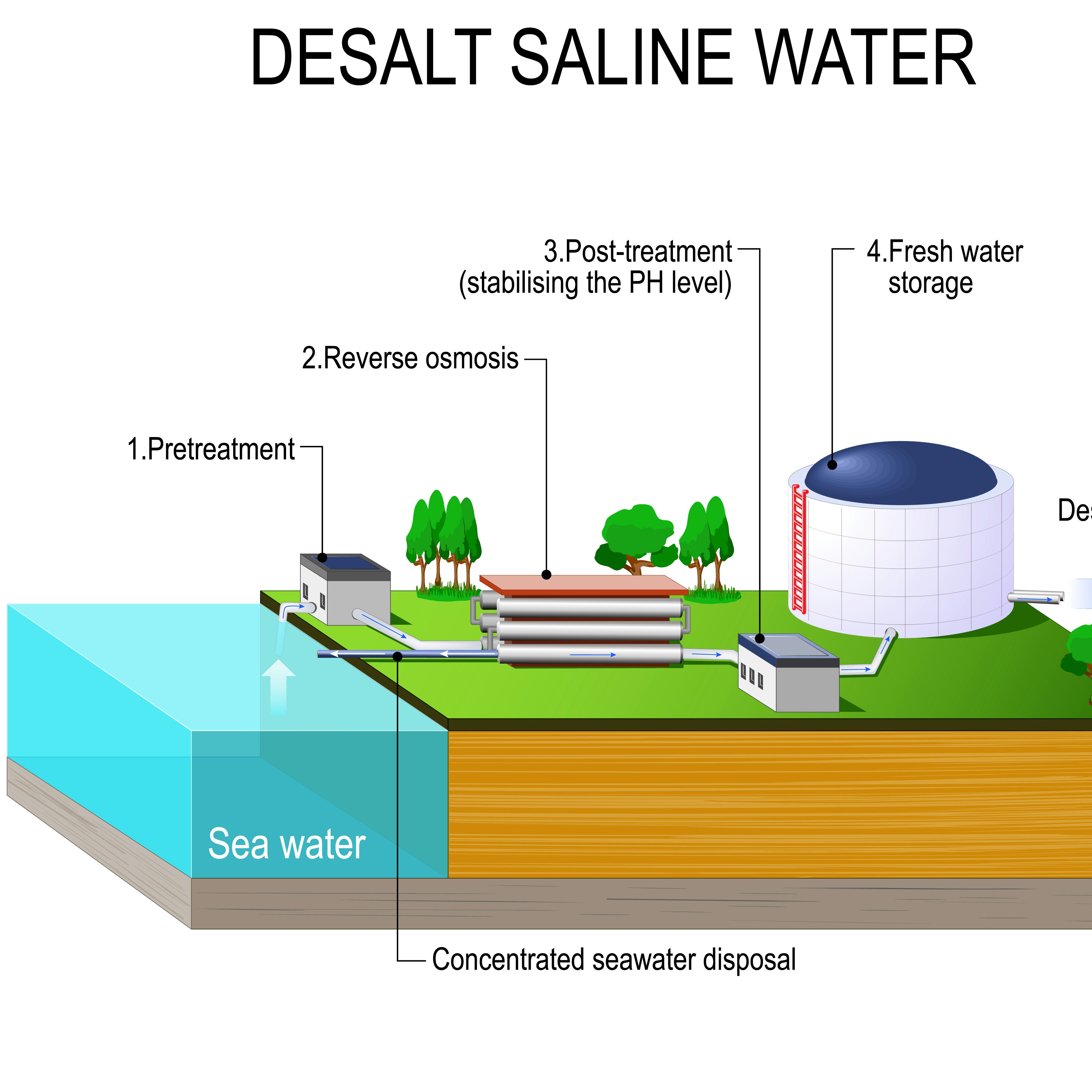
| 6. Desalination (phase 1) | 50 | 8 | 2031 |
| 7. Desalination (phase 2) | 50 | 8 | 2033 |
| 8. Desalination (phase 3) | 50 | 8 | 2035 |
3.4 Evaluating solution stratgies
The information of this water scarcity solution strategy was implemented in the WaterLOUPE risk assessment. By selecting “Western Cape Solution Strategy” in the drop-down menu at the top of this WaterLOUPE dashboard, the impact of the mitigation strategy is visualized in the maps, tables, and graphs of the water scarcity risk assessment:
4. Water Scarcity Actions Wayfinder
water scarcity mitigation and adaptation measures
4.1 Characteristics of measures
This Water Scarcity Actions Wayfinder of measures contains both mitigation and adaptation measures that can be taken up in a water scarcity solution strategy. The sections below provide an information card for each measure that describes the following characteristics:
- dimensions of the measure
- technical and environmental suitability
- social, economic, and political suitability
- benefits and so-benefits
- disadvantages
- measures that are reinforcing within a solution strategy
The measures in this Water Scarcity Actions Wayfinder are ordered according to their size and spatial scale, ranging from basin scale to micro-scale.
Note: This Actions Wayfinder is under development. We are in a continuing process of collecting water mitigation and adaptation measures and information about their characteristics. Please contact us if you want to contribute to the WaterLOUPE initiative with your expertise of water scarcity mitigation measures.
4.2 Catchment/province scale


4.3 Sub-catchment/municipality scale


4.4 Local scale measures


4.5 Micro scale measures